


The National Weather Service (NWS) is monitoring a storm system that will move across the deep south over the weekend.
A Winter Storm Watch is in effect for neighboring Tennessee counties from late Saturday night through Sunday afternoon. A Special Weather Statement was issued for northern Alabama counties, warning that rain Saturday will transition to snow on Sunday morning, with a mixture of snow and a light freezing drizzle expected across the region Sunday afternoon. The system should leave the area Sunday evening.
Snowfall accumulations of half an inch to an inch are expected for valley locations, with higher amounts possible in elevated areas. The NWS said forecasted snow totals are likely to change, and travel impacts are possible in north Alabama.
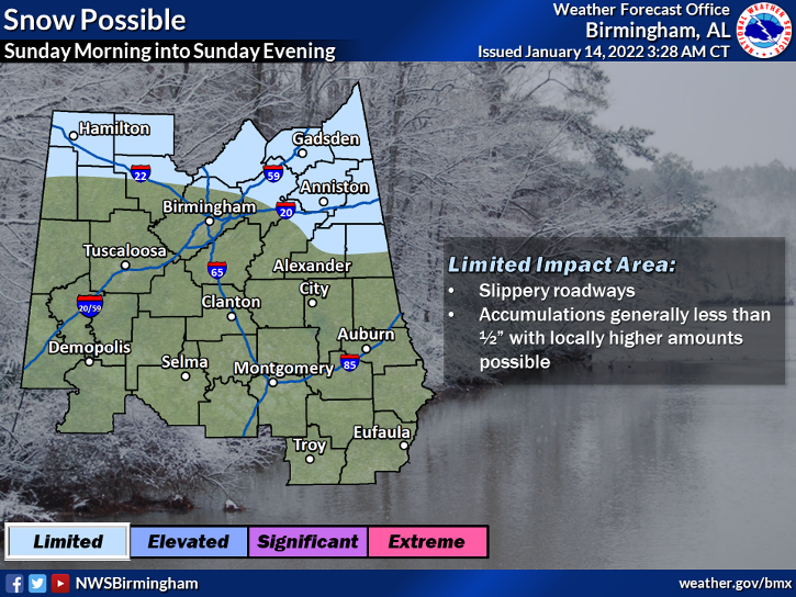
In central Alabama counties, accumulation of snow could occur along and north of Interstate 22 and along and north of Interstate 20 east, of Birmingham. Accumulation is not expected to exceed half an inch in most places. The highest accumulation areas in central Alabama will likely be in the far northeastern counties, primarily Cherokee, Cleburne and northern Randolph Counties.
As the low-pressure system quickly moves out of the area Sunday evening, temperatures will drop rapidly into the upper 20s to low 30s by midnight Sunday. Temperatures will continue to hit below freezing at times through Monday evening.
Dry weather is expected to return for the first half of the week but more moisture will return Wednesday into Thursday.
To connect with the author of this story, or to comment, email [email protected]. Send weather photos to [email protected].


