


The National Weather Service (NWS) is tracking a storm that could bring damaging winds and dangerous storms, including tornadoes, Wednesday and into Thursday. Heavy rainfall could also cause problems in already-soaked areas across the state.
Before the main line of storms enters the state Wednesday afternoon, meteorologists say very strong winds of up to 50 mph are expected. Stronger gusts are possible.
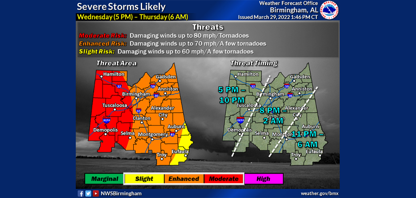
The primary threat will be in west Alabama, where winds of up to 80 mph are possible. However, all of Alabama will see the possibility of serious storms throughout the evening Wednesday and into Thursday morning.
The NWS in Birmingham said these gusts will be strong enough to cause trees to fall.
“Damaging straight-line winds can cause just as much damage or more than a weak tornado,” NWS Birmingham tweeted. “Take severe thunderstorm warnings seriously tomorrow and consider taking shelter for these even if there isn't a tornado warning.”
The tornado threat is a real concern for meteorologists. Possible isolated tornadoes that could form have the potential to be very strong, with a rating of E-2 or stronger.
In central Alabama, 1-3 inches of rainfall is possible. Forecasters said the rain could cause flash flooding in urban areas and areas with poor drainage.
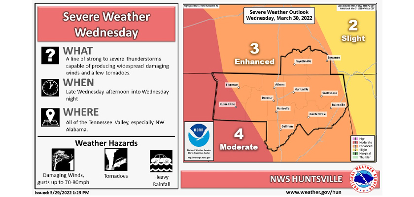
The NWS in Huntsville is watching the entire Tennessee Valley and warning that tornadoes are possible there Wednesday afternoon and into the evening. A Wind Advisory is in effect across much of the state, and people are encouraged to secure outdoor items.
The NWS in Mobile said straight-line winds and tornadoes will threaten the southern part of the state as well. Meteorologists suggest charging all electronic devices to prepare for the possibility of power outages.
With spring breakers out on the Gulf Coast, the NWS service tweeted, “Boaters....Just don't. The Gulf waters will be dangerous with southerly winds of 20 to 30 knots with frequent gusts to gale force has warranted a Gale Warning beginning 10 AM tomorrow through 7 AM Thursday. Seas of 9 to 12 feet.”
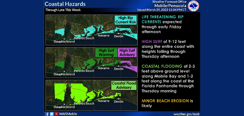
Rip currents and high surf of 9-12 feet will also be possible, along with minor coastal flooding and overwash.
Be sure to stay weather-aware all day and evening Wednesday, and have multiple ways to receive alerts. You can download a weather app, make use of your weather radio and watch local coverage of storms on television or online. Also, listen for local warning sirens if you are outdoors. Identify your safe place with no windows before the system arrives. It is safest to be in a lower-level interior room. Mobile homes are not safe during severe weather. Consider finding a storm shelter or staying with family or friends who live in a sturdy building.
To connect with the author of this story, or to comment, email [email protected].


